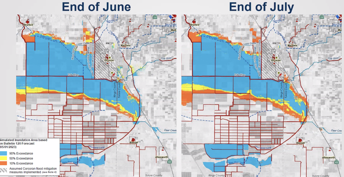
An "inundation" map from the California Department of Water Resources shows the potential for flooding in the Tulare Lake basin this summer. DWR image
Written by Gabriel Dillard
The communities of Corcoran and Stratford will likely be spared any flooding as one of the Sierra’s largest snowpacks on record melts this summer, according to the latest scientific modeling.
The California Office of Emergency Services (CalOES) and California Department of Water Resources (DWR) hosted a media briefing Monday to present the latest flood modeling for the Tulare Lake basin. It shows that flood control efforts and environmental conditions are likely to spare Corcoran and Stratford from damaging flood surges as snowmelt travels down the four rivers — the Kings, Kaweah, Tule and Kern — that feed Tulare Lake.
That forecast stands in contrast to conditions in April, when surface water elevation stood at 186.3 feet, said Mehdi Mizani, DWR water resources engineer.
Surface water elevation is a measurement above sea level that gives water managers an idea of the potential for flooding. With the levee that protects Corcoran from Tulare Lake standing at 188 feet, there was not much wiggle room. That’s why Gov. Gavin Newsom earlier this month announced $17.2 million in funding to raise the levee to 192 feet.
With the latest modeling, the surface water elevation is expected to be in the 181-184 feet range as summer heat begins to melt the snowpack.
“The most serious risk may have been averted, but we don’t know what we don’t know yet,” said Brian Ferguson, CalOES spokesperson. “We are very pleased things are trending in the right direction.”
In terms of land area, there were 103,000 acres of land in Tulare Lake covered by water as of May 8. At the height of runoff season, that amount is expected to reach 117,000 acres at the highest probability and 132,000 acres at the lowest probability.
Those figures are well below the most dire predictions after California was slammed with a series of atmospheric river rain events that began around mid-March.
“We are in significantly better shape than we were several weeks ago,” Ferguson said.
State water managers and Gov. Newsom himself are attempting to make it easier to divert these flood waters to areas where it can used to recharge the underground aquifer.
An estimated 91,625 acre-feet of water has been diverted from flood flows for groundwater recharge on 88,562 California acres this season, said Paul Gosselin, DWR deputy director for statewide groundwater management.
He said the state has an estimated recharge capacity of 3.3 million acre-feet this year, with a goal of reaching 500,000 acre-feet of recharge annual.
Local water agencies are doing their part to take this water with temporary pumping programs to bank water underground. The Fresno Irrigation District deployed such an operation last month in the Kings River watershed, with several more in the planning stages, Gosselin said.
Should all these recharge projects run for four months, an estimated 192,000 acre-feet of water would be diverted to the aquifer, Gosselin said.
If flooding does outpace the forecast, Ferguson said CalOES has “prepositioned” resources in the region to combat the influx. These include 2 million sandbags, 30,000 “super sacks” that can be dropped by helicopters to close breaches and two miles of “Hesco” barriers that can be filled with soil and have been used as warzone fortifications and for flood control.
The biggest takeaway, Ferguson said, is that the worst does not appear yet to come.
“We have been very lucky with how this has played out today,” he said.
Related Posts
-
 Raisin Outlook 2026: Trends leave industry leaner, ready to compete Posted: May 4, 2026 at 9:45 pm
More than 1,500 raisin growers in the Central Valley produce
Read more » -
 Farm bill clears House with wins for Valley growers, questions on food aid Posted: April 30, 2026 at 3:33 pm
The House passed a $390 billion farm bill Thursday after
Read more » -
 Fresno man sentenced in $5M canola theft scheme Posted: April 28, 2026 at 10:04 pm
Richard Best, 72, of Fresno, was sentenced Monday by the
Read more » -
 Inside HotSpot AG, the Central Valley firm teaching the world to farm smarter Posted: April 27, 2026 at 3:48 pm
A Hanford company that helps Central Valley growers manage their
Read more »
Central Valley Biz Blogs
-

BLOG: Introducing the Philanthropy Excellence Awards, celebrating community impact
Posted: May 6, 2026 at 1:22 pm
At The Business Journal, storytelling has always been at the heart
Read more » -

BLOG: Accessibility isn’t optional — and it’s coming for small business
Posted: May 5, 2026 at 12:10 pm
As a website developer I tell people that search engine
Read more »