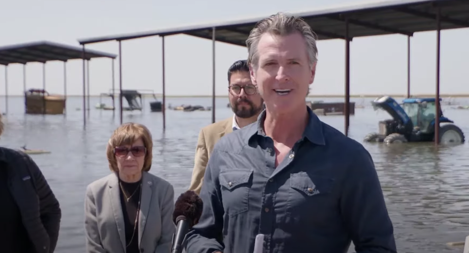
Governor Gavin Newsom speaks to the public regarding recent flooding in Tulare County. (screenshot of press conference on April 26)
Written by AMY TAXIN and JAE C. HONG Associated Press
Ron Caetano is packed and ready to go. His family photos and valuables are in the trailer and he’s put food in carry totes. He moved the rabbits and chickens and their automatic feeders to higher ground.
He and his family and dogs could get out in less than an hour, they figure, should more heavy rain or hot weather melt so much mountain snow that gushing water overwhelms the rivers and channel that surround their tight-knit, rural Central California community and give it its name, the Island District.
“The water is coming this way,” said Caetano, who started a Facebook group to help organize his neighbors. “I am preparing for the worst and praying for the best and that’s all we can do.”
After more than a dozen atmospheric rivers dumped epic rain and snowfall on California, a reservoir that stores water upstream is expected to receive three times its capacity in the coming months. Caetano and his neighbors in the tree-lined Island District, home to a school, pistachio orchards and horse ranches about halfway between Los Angeles and San Francisco, could soon be marooned by rising rivers or flooded out.
Water managers are concerned that the spring snowmelt in the Sierra Nevada will be so massive that the north fork of the Kings River won’t be able to contain it and carry it toward the Pacific Ocean. Much of the water also is being channeled into the river’s south fork, which winds through the area near the small city of Lemoore to fill a vast basin.
More than a century ago, that basin was an enormous body of freshwater known as Tulare Lake, the largest west of the Mississippi River. It would grow in winter as snowmelt streamed down from the mountains. But over time, settlers dammed and diverted waterways to irrigate crops, and the lake went dry. Now, Tulare Lake reappears only during the rainiest years, like this one, covering what is now a vast swath of farmland with water.
Today, paved roads vanish beneath the lake’s lapping waves and utility poles and trees jut out above the water, vestiges of land-living put on hold. Fields that typically grow wheat, tomatoes, and other crops lie underneath.
David Merritt, general manager for the Kings River Conservation District, said the Pine Flat Reservoir about 50 miles (80 kilometers) upstream can hold up to 1 million acre feet of water, but is expected to receive more than 3 million acre feet this spring from the melting snow. Officials have been forced to increase the flow of water out of the reservoir to make space for more, Merritt said.
“Once we’re at capacity, now you’re putting a lot of stress on those conveyance channels,” Merritt said. “It’s a very fast moving stream and it’s very deep right now.”
Island District residents have revived a decades-old network of neighbors for the first time since 1983 to assist each other in the event of a crisis. The last time the Island Property Protection Association activated, there was no such thing as text messages or even emails to quickly spread the word, said Tony Oliveira, a former county supervisor and the network’s administrator.
In a week, more than 200 people volunteered to help neighbors through the network, and the group’s website received more than 4,000 hits.
“It’s going to be four months of holding our breath,” Oliveira said.
The winter rains were welcomed by California’s parched cities and desperate growers, who have been grappling with intense drought for the past several years. The state has long tended toward wet and dry periods, but scientists at University of California, San Diego’s Scripps Institution of Oceanography have said they expect climate change will lead to drier dry years and wetter wet years.
What will determine how communities fare now is how quickly the weather heats up. If temperatures remain cool, snow will melt slowly, with water gradually flowing from the mountains. But a hot spell could send massive amounts of water churning through rivers that could potentially overflow, officials said. A beaver or a squirrel that tears a hole in a levee could also bring trouble.
Rising temperatures this week have many residents on edge. Park officials announced plans to temporarily close part of Yosemite National Park starting Friday due to the threat of flooding. Reservations for campgrounds and lodging in eastern Yosemite Valley will automatically be canceled and refunded.
Michael Anderson, California’s state climatologist, said water inflows into some reservoirs are expected to double though he doesn’t expect the warming trend to cause immediate flooding in residential areas.
But in the coming weeks and months that could change. Gov. Gavin Newsom visited the reemerged lake Tuesday and said the worst is likely yet to come as more water reaches the basin.
“Where we’re standing likely will be underwater in a matter of weeks, if not months,” he said. “That’s very sobering.”
It isn’t the first time Kings County, home to 150,000 people in the fertile San Joaquin Valley, has faced these challenges.
Many longtime residents recall when Tulare Lake reappeared 40 years ago. Officials believe crops will remain under water much longer this time due to the massive snowpack, said Dusty Ference, executive director of the Kings County Farm Bureau. To date, more than 60,000 acres of farmland (242 square kilometers) have flooded, he said.
It also returned on a smaller scale in 1997, said Nicholas Pinter, associate director of the University of California, Davis Center for Watershed Sciences. He said the lake has always fluctuated in size due to California’s highly-variable water cycle, and farmers have long known there would be periods like this.
“It has been an engineering problem all along,” he said. “This is a bathtub with no drain.”
Near the lake, the city of Corcoran, which is home to 22,000 people including 8,000 state prisoners, began emergency construction to raise a levee that protects the community. The water behind the levee is already at 178 feet (54 meters), just 10 feet (3 meters) below the top. Officials want to raise the levee another 3.5 feet (1 meter), city officials said.
“If that water rises above that amount, we will have water coming into our city and we will be in a critical situation,” said Greg Gatzka, Corcoran’s city manager.
In the Island District, residents don’t have a levee to protect them. They snap photos of wooden sticks placed near waterways to gauge water levels and banks and post them online to keep others informed. They’re helping place sandbags on elderly neighbors’ property and paying close attention to reports from water and county officials, and from each other.
Oliveira, whose family has lived in the area for generations, said he remembers moving cattle and horses when the rains came in 1983, and will do the same this time, if necessary.
“We’re farmers. We have bulldozers and backhoes, we have trailers. We can bring things to bear sometimes faster than the public agencies can,” Oliveira said. “The people who live in the Island are just kind of those neighbors taking care of neighbors.”
___
Taxin reported from Orange County, California.
Associated Press climate and environmental coverage receives support from several private foundations. See more about AP’s climate initiative here. The AP is solely responsible for all content.
Related Posts
-
 Raisin Outlook 2026: Trends leave industry leaner, ready to compete Posted: May 4, 2026 at 9:45 pm
More than 1,500 raisin growers in the Central Valley produce
Read more » -
 Farm bill clears House with wins for Valley growers, questions on food aid Posted: April 30, 2026 at 3:33 pm
The House passed a $390 billion farm bill Thursday after
Read more » -
 Fresno man sentenced in $5M canola theft scheme Posted: April 28, 2026 at 10:04 pm
Richard Best, 72, of Fresno, was sentenced Monday by the
Read more » -
 Inside HotSpot AG, the Central Valley firm teaching the world to farm smarter Posted: April 27, 2026 at 3:48 pm
A Hanford company that helps Central Valley growers manage their
Read more »
Central Valley Biz Blogs
-

BLOG: Introducing the Philanthropy Excellence Awards, celebrating community impact
Posted: May 6, 2026 at 1:22 pm
At The Business Journal, storytelling has always been at the heart
Read more » -

BLOG: Accessibility isn’t optional — and it’s coming for small business
Posted: May 5, 2026 at 12:10 pm
As a website developer I tell people that search engine
Read more »