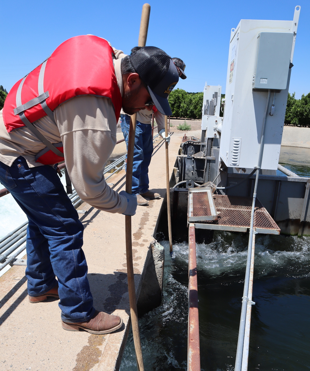
A Fresno Irrigation District worker cleans debris from a long-crested weir, a newer technology that makes water delivery more efficient.
Written by Edward Smith
As Covid-19 and social unrest dominates news headlines, another problem beneath Central Valley residents’ feet is coming to the surface. This was the first year plans had to be submitted for many irrigation districts throughout the state of California as part of 2014’s Sustainable Groundwater Management Act (SGMA).
Sustainability plans developed by groundwater sustainability agencies (GSA) outline how water users can restore depleted water sources. But fights have arisen and disputes about the reliability of those water sources have come to light.
Many GSAs say they have a good handle on how they can keep consistent water supply to growers and ranchers. But experts stand by their assessments of the impact SGMA may have on farming in the Central Valley.
Water agencies have five years to prove they’re correcting decades of overdraft.
The plans address six different issues — chronic lowering groundwater levels, reduction of groundwater storage, seawater intrusion, land subsidence, water quality degradation and depletion of interconnected surface water.
A fragmented fight
Agencies in the different sub-basins need to collaborate and form a unified plan to show the state they correct the six criteria.
In the Madera sub-basin, a joint plan developed by the different agencies was rejected because one GSA, New Stone Water District GSA, did not sign onto the coordination agreement, costing them $500,000 for a grant to develop new wells.
In the East Kaweah District, planners’ immediate goal is to not let the water table fall 200 feet below the surface. But their ultimate objective is to get water levels to 100 feet. Michael Hagman, executive director, says their plan has been criticized by a number of groups who say that those minimum thresholds will drain domestic wells. Hagman says that under their plan, water will eventually be raised to 100 feet. The minimum threshold of 200 feet below the surface is only to give them flexibility.
Unreliable data could make coming to an agreement even harder, says Sarge Green, project director of the California Water Institute and the Center for Irrigation Technology. The problem starts with accessing wells in sub-basins. Many wells lie on private property and landowners may be hesitant to have their wells examined. Wells have also been placed near power lines because of the cost to run power underground, so the spacing of the wells may not give a good picture of a district’s basin.
Newer wells also don’t give the most reliable data. Many private wells were made to be temporary and don’t show how groundwater acts in different years.
“They have the opportunity to make mistakes and have the opportunity then to improve them,” said Green. “It’s a glideslope, but the truth is we do not have the water to support the land that we have and that’s been fairly well demonstrated.”
Effect on farming
Earlier this year, a study out of UC Berkeley from economists David Sunding and David Roland-Holst forecast that over the next 20-30 years, a million acres of farmland in the state could be lost due to water restrictions, roughly one-fifth of acreage in cultivation in the San Joaquin Valley.
GSAs insist their plans are enough to keep farmers supplied with the water they need through the future.
“We’ve already been progressive on making sure every particle of water delivered in the district is effective and efficiently used,” said Kiti Campbell, supervisor of resources with Westlands Water District. The district has compiled data over the years to establish a reliable model of how water flows there.
Out of that data, the District determined the need to permanently fallow 96,000 acres of farmland in response to water needs. Campbell says that their proactive action will prevent any need for “a drastic increase” in fallowing numbers. They estimate a need to fallow 160,000 acres this year — the same amount as last year.
During wet years, they have put more water into their aquifer than before, giving them reserves to fall back on in times of need. Also, 95% of growers have turned to efficient methods such as drip irrigation. The water table has recovered “pretty significantly” since the drought, Campbell said.
But dry years could be a thorn in the side of groundwater plans. Because of the drier-than-normal rain year, farmers on Fresno County’s Westside had only a 20% allocation from the Bureau of Reclamation. Of the 1.195 million acre-feet of entitlement water the district uses, that means only 203,000 acre-feet of water will be delivered from the Central Valley Project Water Supply. They anticipate drawing up 448,000 acre-feet of water and transfering 200,000 acre-feet. That accounts for 851,000 acre-feet of water.
Some feel that the positive outlook misses problems lying below the surface. Kevin France, CEO of SWIIM System, says that what’s being reported by GSAs and what is in the basin are two different things. His company monitors water usage on farms. The technology has been used to settle disputes between parties along the Colorado River.
“Growers are seeing restrictions now or they’re seeing the writing on the wall that in some period of time — whether it’s five years, six years, the restrictions are going to be such, or the over-allotment fees are going to be such, that it’s going to put a good number of them out of business,” said France.
He has clients in Kern County who are signing up solely to get recharge credits and then getting out of the business.
The Kaweah sub-basin is overdrafted by 80,000 acre-feet every year, says Hagman. East Kaweah GSA covers a quarter of the basin, and they need to reduce overdraft by 28,000 acre-feet. Hagman says 60% of that problem could be solved with projects connecting Linmoore Irrigation District to the Central Valley Water Project and taking excess water from the Friant-Kern Canal.
The overdraft in the entire San Joaquin basin is estimated at 2 million acre-feet, according to Hagman. Of that, East Kaweah makes up 5%. So, if growers in the district had to make the water reductions necessary to meet those cuts, that would mean 40,000 acres fallowed in the area between Lindsay and Strathmore — roughly 10% of the entire acreage in the area.
Determining winners and losers
Temporary fallowing may be the future, says Green. Growers may dismiss annual crops following dry years. Solar projects may help permanently fallowed land turn a profit.
Among others, areas in Kern County are “ground zero for potential loss of land,” said Green. Strategies are coming out on how to stave off land loss. That includes prioritizing water to permanent crops. This could mean low-value crops such as alfalfa or corn will be the first hit, says Green. For dairies already struggling to survive, that could make the food source for their cattle less reliable.
On the horizon may be trading platforms for growers. France said he saw the same thing in Colorado during its drought. His company monitors in-flows and out-flows of water for farmers. Colorado farmers engaged in “buy-and-dry” where farmers traded or sold their water allocations to one another if they felt they couldn’t be profitable. His company is already working on a platform to service those trades.
Green says it would be easy to service trades within sub-basins, but legal problems may arise when rights to water leave the area.
Campbell with Westlands said that while they would not participate in those trades, they have language in their sustainability plan that allows for those trades to happen.
“That’s a story to be written in the future. I don’t know how these markets will work,” said Green. “Because water will go to money, there’s no question about it.”
Related Posts
-
 ENZO Olive Oil wins Best of Class at one of the world’s top olive oil competitions Posted: March 23, 2026 at 5:43 pm
ENZO Olive Oil Co., an organic extra virgin olive oil
Read more » -
 UFW advocates for farmworkers, but represents fewer now than during Chavez’s era Posted: March 20, 2026 at 2:33 pm
Most farmworkers in the United States today aren't represented by
Read more » -
 $540M federal investment to revamp Central Valley water infrastructure Posted: March 17, 2026 at 3:20 pm
California's Central Valley is set to receive its largest-ever federal
Read more » -
 Fresno County’s Raw Farm says ‘no’ to recall after suspected outbreak linked to cheese Posted: March 16, 2026 at 4:52 pm
Raw Farm in Fresno County is under investigation for its
Read more »
Central Valley Biz Blogs
-

BLOG: The Central Valley — California’s manufacturing bright spot
Posted: March 13, 2026 at 2:07 pm
If you follow the headlines, you might conclude that manufacturing
Read more » -

BLOG: California’s tribal casinos trample smaller cardrooms with new regulations
Posted: March 11, 2026 at 9:18 am
While writing a book about California politics a quarter-century ago, I devoted
Read more »