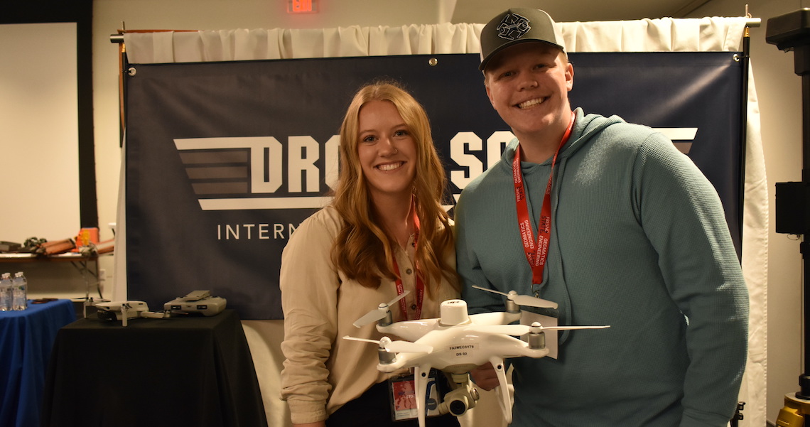
Micarah Stotts is the CEO of Drone Scout in Clovis, and Judah Roseno is her chief pilot. They have been building their book of business bringing aerial photography services for surveyors. Photo by Frank Lopez
Written by Frank Lopez
As construction activity for both commercial and residential projects in the state is on an upswing, there is a need for people to do the work before construction work starts — land surveyors.
Last month, Fresno State’s Geomatics Engineering Club hosted the 62nd annual Geomatics Engineering Conference at the Lynda & Stewart Resnick Student Union on campus.
The two-day conference invites geomatic engineering students to connect with geomatic engineering companies and professors to discuss the fields of land surveying, photogrammetry, unmanned aerial systems, Geographical Information Systems (GIS) and Global Positioning Systems (GPS).
Over the course of two days, nearly 20 guest speakers from industry, government, and academia shared with students about the various topics.
Though it is a necessary aspect of engineering and construction, geomatics is not a popularly known discipline to most.
Geomatics is the measurement, analysis, and management of data relating to the earth and the built environment.
Geomatic engineers use sensor equipment on the ground, in the ocean, in the air and on satellites to gather data to develop information systems that are used for land use planning and landscape analysis.
Claudia Luna, president of the Student Association of Geomatics Engineering (SAGE), said the event gives students opportunities to network and dip their feet into the professional world.
Luna said that that when young people are being nudged towards engineering as a career choice, they are pushed towards fields such as architecture or civil engineering, with geomatics often being overlooked.
“There isn’t enough knowledge about what geomatics engineers do,” Luna said. “We get taken for granted. What we do — our technologies, our techniques — they are involved in every aspect of modern life.”
Luna listed the everyday applications of these technologies, such as GPS in our phones and remote sensing with products like Roomba vacuums.
She said land surveyors are the people who let builders know all the dimensions, angles and boundaries necessary for construction projects.
It is not only the construction industry that depends on the work of geomatic engineers, but the agriculture industry as well.
GIS is used to see how much farmland has been depleted in the last few decades. Infrared satellite images are used to tell farmers if they are overwatering their crops or affected by disease.
Land, sea and air
Copper Aerial, a San Diego County aerial mapping and Light Detection and Ranging (LiDAR) service provider, has offices on the East and West coasts as well as Mexico.
Business Development Associate for Cooper Aerial Tom Warren covers the California market and attended the conference at Fresno State.
He said that cartography, the mapping of land, has come a long way with the advent of aerial photography, satellites and land-based technologies.
LiDAR, like RADAR, detects the presence and volume of distant objects, but LiDAR picks up light waves while RADAR picks up radio waves.
“Aerial mapping is a very consistent business,” Warren said. “Whether we are developing land, or modern-day buildings, suburban construction of homes, infrastructure items and so forth, there is always a need to apply aerial surveying to do ground surveying.”
Recently, there has been more attention for watershed applications, and by using hydrology, land surveyors are able to determine which areas are more prone to flooding.
Cities, counties, and government agencies have had a strong interest for these services to mitigate flooding in the near future — and even 100 years into the future.
Land surveyors also analyze land that has suffered natural disasters, such as forest fires, to accurately map the land and use data to make mudslide predictions.
Scout and out
Utilizing these newer technologies for her own business is Micarah Stotts, CEO of Drone Scout, a drone service company in Clovis providing drone data and aerial photography and videography for surveyors.
Stotts opened her business last year after graduating from Fresno State’s Craig School of Business. She runs the company with fellow CEO Jayna Krueger and Chief Pilot Judah Roseno.
The team spent most of last year preparing to launch, and though they are a startup company, Stotts said they are growing.
Stotts said she became interested in drones after a family member received a drone pilot’s license for their job. Through networking with other drone operators, Stotts said land surveyors expressed a need for what drone companies are doing.
It is more difficult for a land surveying company to maintain a drone program themselves, she said. It’s hard to keep up with the technology and software, Stotts said.
A solid mapping drone with the entire mapping system base station, such as the DJI Phantom 4 RTK Drone Scout uses, comes with a price tag of approximately $15,000.
Recreational drone flying does require a free training course and safety test, and drones need to be registered with the Federal Aviation Administration, but commercial drone flying requires a Part 107 license.
“Business is good. It’s slow, but it’s steady and we are gaining experience and trust with clients,” Stotts said. “We don’t want to just grow in the fastest way possible. We are hoping to grow by trust and connections with local people in the industry.”
Drones are grounded when it rains, so the recent storms left activity slow for Drone Scout.
Drone Scout has consistent clients currently, and the team is excited for what this new year will bring.
Related Posts
-
 Wonderful Company expands scholarship program to Avenal and Firebaugh students Posted: September 17, 2025 at 3:03 pm
The Wonderful Company announced Wednesday that its Wonderful Community Scholarship
Read more » -
 Tulare pitches 100-acre adventure park to boost tourism, jobs Posted: at 2:53 pm
Tulare hopes to leverage its central Highway 99 location to
Read more » -
 FDA takes aim at Hims & Hers, weight loss drugs in new advertising blitz Posted: September 16, 2025 at 4:48 pm
(AP) — For the first time, federal health officials are
Read more » -
 Central Valley crop nutrition leader announces private equity growth partnership Posted: at 3:46 pm
A leading Central Valley ag company has announced a partnership
Read more »
Central Valley Biz Blogs
-

BLOG: Prescription Affordability Crisis: How SB 41 Could Make a Bad Situation Worse
Posted: September 12, 2025 at 12:23 pm
In recent months, Governor Gavin Newsom and the state legislature
Read more » -

BLOG: Two years later, Californians still don’t know full impact of the $20 fast food wage
Posted: at 8:49 am
As the California Legislature churns toward the end of its
Read more »